Products
-

PSR-5000X Wireless Remote Control Mobile Panoramic Slope Monitoring Radar
PSR-5000X Wireless Remote Control Mobile Panoramic Slope Monitoring Radar
I. Product Overview
The PSR-5000X Emergency Ultra-Portable Slope Monitoring Radar is based on the circular synthetic aperture radar system, wideband frequency-modulated continuous wave signal form, and phase differential interferometric measurement technology. It has the characteristics of all-round 360° large-scale coverage, fine deformation measurement, and all-day and all-weather environmental adaptability. At the same time, especially for the rapid response requirements of emergency rescue tasks, it focuses on the design of being lightweight, small-sized, portable, and low-power consumption, forming industry-leading indicators in terms of volume, weight, power consumption, and portability.
II. Product Features
(1) The deformation measurement accuracy reaches 0.1mm, and the highest data update rate is 30 seconds per time, with high sensitivity in deformation monitoring.
(2) It has strong microwave penetration and the ability to monitor all day and all weather, without being affected by rain, snow, fog, smoke, dust, etc.
(3) Adopting the circular arc imaging and continuous wave radar system, it can monitor 360° in all directions, with no blind areas in terms of angle and distance.
(4) The body adopts an edge computing architecture, and all information processing is completed inside the body. A satellite gyrocompass (optional) and a wireless router (optional) can be built-in to achieve single-unit deployment and work, making the installation and configuration quicker.
(5) It has the function of remote control for electric pitch angle adjustment (optional), which can be flexibly adapted to the monitoring of high mountain valleys with large drops.
(6) It is extremely lightweight and portable, weighing only 8kg. It can be carried quickly to the rescue site by a single person either by hand or on the back. After folding, the size is only 0.5×0.3×0.25m, and it can be placed in a 24-inch storage and transportation box, meeting the requirements for random checked baggage on civil aviation flights.
(7) The software adopts a B/S architecture. It can be monitored on-site through a LAN/WiFi display and control laptop, or remotely monitored through the 4G/5G mobile network in the cloud.
(8) It has an original and advanced adaptive atmospheric disturbance compensation algorithm, with the error caused by atmospheric disturbance being less than 2mm per day.
(9) It has an original adaptive monitoring and early warning function. Monitoring points and monitoring areas can be added manually or automatically, and it has 4 levels of audible and visual, SMS, and email alarms that can be set.
(10) It has an original three-dimensional terrain matching and rendering algorithm, with a fast rendering time. The three-dimensional terrain matching accuracy reaches the sub-meter level, and the computer configuration requirements are low.
(11) It has good environmental adaptability, with a protection level of IP66. The lowest working temperature can reach -40℃ (with the optional low-temperature kit), and it supports continuous outdoor work without protection.III. Main Technical Indicators
(1) Maximum Detection Distance: ≥ 5000m
(2) Deformation Accuracy: ≤ 0.1mm (RMS, at all azimuth angles)
(3) Single Scan Coverage Angle: ≥ 360°×40°
(4) Electrically Controlled Pitch Adjustment Angle: ≥ ±45°
(5) Range Resolution: ≤ 0.3m (at all azimuth angles)
(6) Azimuth Resolution: ≤ 7.5mrad (at all azimuth angles)
(7) Acquisition Period: Configurable between 0.5 and 4 minutes
(8) Power Consumption of the Whole Machine: ≤ 45W
(9) Weight of the Whole Machine: ≤ 8kg
(10) Maximum Size after Folding and Storage: ≤ 0.5m
(11) Transportability: Can be carried by a single person by hand and can be checked in on flights and high-speed trains.
(12) Operating Temperature Range: -40~55℃
(13) Protection Level: ≥ IP66
(14) The main unit adopts edge computing, and all processing is completed inside the machine without the need for external processing equipment.
(15) The main unit has a built-in satellite gyrocompass, which supports independent positioning and orientation, making the deployment convenient and quick.
(16) The main unit has a built-in WiFi/4G wireless communication function, eliminating the need for additional communication equipment.
(17) It comes with a sunshade and has a built-in automatic hot and cold temperature control system.
(18) It supports the reinforcement and stabilization of each leg of the tripod with heavy objects.
(19) It has means for quickly obtaining and processing three-dimensional terrain temporarily, which is convenient for emergency tasks.
(20) It is equipped with a power grid protection transport box, with a built-in storage battery (an offline battery life of 72 hours, and it can be used while charging). It can be connected to an external solar panel and mains power (automatically switches to the storage battery when the mains power is cut off), and has a backup network access (the weight of all transport boxes ≤ 35kg). -

PSR-3500-S Rolling Stone Radar/ Portable Sudden Geological Hazard Monitoring Radar
PSR-3500-S Portable Sudden Geological Hazard Monitoring Radar
I. Product Overview
The PSR-3500-S Portable Monitoring Radar for Sudden Geological Disasters is a portable alarm system for sudden geological disasters that adopts large-scale MIMO array technology and advanced moving target detection algorithms, and integrates technical means such as radar, audible and visual alarms. It can continuously monitor large-scale slopes, and provide real-time alarms for rockfalls, debris flows, and collapses. It has the advantages of good environmental adaptability, wide coverage, fast update, quick positioning, and being suitable for single soldiers to carry.
II. Product Features
- Ultra-long distance and large-scale detection
With a long distance of 3.5 kilometers, and the monitoring accuracy is not affected by the distance. - Ultra-high precision monitoring
With a maximum sub-millimeter level accuracy of 0.1mm, it can finely monitor early slight deformations and provide faster and more accurate warnings. - Multi-functional detection
Integrates audible and visual alarms and multiple sensing detections by radar. - Ultra-high speed monitoring
With a moving target monitoring speed of 10m/S, it can quickly identify potential falling objects. - All-day, all-weather, fully automated detection
It can conduct 24-hour, all-day, all-weather, and fully automated detection. - Lightweight
The whole machine adopts an integrated, lightweight and small handheld design, which is easy to transport and deploy.
III. Main Technical Indicators
3.1 Main Unit Parameters:- Maximum Monitoring Distance: 3500M
- Maximum Monitoring Distance for Moving Targets: 1500M
- Deformation Monitoring Accuracy: Sub-millimeter level, 0.1mm
- Maximum Moving Detection Speed: 10m/S
- Acquisition Interval: 1-6min
- Resolution: 0.3m×3mrad
- Monitoring Range: 120°;
- Data Acquisition Time: ≤1min
- Monitoring Conditions: 24 hours, fully automatic detection
- Power Supply Requirements: AC220V/DC 48V.
- Protection Level: IP66;
- Operating Temperature: -30℃ — 60℃;
- It has a hardware self-recovery function, and a repair interface is reserved. Repair accessories can be inserted to automatically restore the factory settings;
- It is equipped with radar data playback software, which can automatically play back the echo signal waveform and view the calibration signal;
- It has a built-in GNSS function and can achieve differential positioning;
- It has an automatic orientation function;
- It has the timing function of the Beidou Satellite Navigation System at the atomic clock level, and the frequency accuracy is better than ±0.5ppb (measurement result within 24 hours);
- The radar system is integrally integrated with a camera for scene monitoring. The connection line between the camera and the radar system is not exposed. The video monitoring function interface and the radar system control system interface are integrally integrated, and the scene image can be captured through the radar system control system interface;
- The system connection is simple. The connection lines of each functional module of the radar should preferably be routed inside the system, and the number of connection cables of the entire radar system is ≤4.
4.2 Software Parameters: - Data collection and deformation processing are directly carried out at the local end, and the automatic processing of radar echo imaging, interference processing, and micro-deformation inversion is completed;
- The software can identify the running status of the radar and the azimuth positioning mechanism, and the running status of the azimuth positioning mechanism and the scanning running position can be viewed in real time through the software;
- It can realize the registration of radar monitoring data and the three-dimensional terrain, and automatically register according to the submitted point cloud data; it supports the integration of UAV modeling, CAD three-dimensional modeling, laser three-dimensional point cloud modeling data and radar data;
- Effectively manage the monitoring data, and be able to query and analyze the data by time, day, week, month, etc.;
- Provide a three-dimensional visual operation interface, and users can conduct data analysis of single points and regions;
- Provide analysis methods for displacement, speed, and acceleration by point and by region;
- Have the functions of deformation color display, email alarm, and SMS alarm warning methods;
- The functions of displaying deformation values, deformation speeds, and acceleration curves in the ways of extreme values and averages can be selected. They can be displayed separately in the ways of extreme values and averages, or can be displayed in combination;
- Provide the setting of alarm thresholds for alarm variables such as deformation values, deformation speeds, deformation accelerations, and cumulative deformation values. The selection of alarm variables can be a single one, or any combination of them, and the alarm time interval can be set;
- The monitoring area selection methods include straight-line polygons, curved-line polygons, etc. It can indicate the positions of at least three points with the maximum deformation in the area, and can display the deformation, deformation speed, and deformation acceleration curves of the point with the maximum deformation;
- Be able to diagnose the overall running status of the radar system and provide status and diagnostic information, be able to monitor the radar waveform status, data coherence quality, and scanning position running status in real time, and achieve rapid positioning of faulty modules;
- Provide a variety of data display and query methods: real-time data, daily data, weekly data, monthly data, annual data;
- Have the functions of distributed correction of space-varying atmospheric phase and multi-level slope interference phase unwrapping;
- Be able to diagnose the overall running status of the radar system and provide status and diagnostic information, be able to monitor the radar waveform status, data coherence quality, and scanning position running status in real time, and achieve rapid positioning of faulty modules.
- Ultra-long distance and large-scale detection
-

JJB150 150 Meters Laser Methane Telemetry Instrument
JJB150 150 Meters Laser Methane Telemetry Instrument
I. Product Overview
When the laser emitted by the telemeter passes through the natural gas leakage gas cloud, methane gas will absorb this laser. The absorbed laser is reflected back to the telemeter by an object. After data collection and processing, the concentration information of the methane gas cloud is obtained.
II. Product Features
- Color liquid crystal touch screen
- Millisecond-level response
- Long detection distance
- Long service life
- Methane gas detection
- Strong anti-interference ability
III. Main Technical Indicators
- Detected Gas: Methane
- Detection Range: Multiple ranges are available; (0 – 5000) ppm.m, (0 – 10000) ppm.m, (0 – 50000) ppm.m, (0 – 100)% LEL
- Minimum Detection Limit: 5 ppm.m
- Telemetry Distance: (0 – 100) m
- Display Mode: 2.4-inch LCD
- Working Power Supply: 7.4V, 3000mAh rechargeable lithium-ion battery
- Alarm Volume: ≥ 60 db
- Alarm Display: The value changes with the concentration value, and it is displayed in a curve.
- Response Time: 0.1s
- Standby Time: Not less than 10h
- Ambient Temperature: (-10 – 50) °C
- Relative Humidity: (20 – 93)% RH
- Accuracy Grade: ±3%FS (for flammable gas)
- Weight: 0.8 Kg
- Product Dimensions: (180X180X80) mm
-

Underwater rescue cutting tool Shoulder-back metal arc amphibious cutting tool LT-200
Underwater rescue cutting tool Shoulder-back metal arc amphibious cutting tool LT-200 1.Overview This set of products is easy to operate, safe and reliable, low noise; It dissolves most substances. It is used for fast cutting of various metals and non-metals (including cast iron, stainless steel, concrete, bulletproof glass, titanium and aluminum alloy, etc.) on land and underwater. It can complete drilling, cutting or excavation work in a short time, produce high temperature meta... -

XTV-F8 Amphibious all-terrain prairie fire vehicle 8×8
XTV-F8 Amphibious all-terrain prairie fire vehicle 8×8 1.Overview Amphibious all-terrain grassland fire extinguishing vehicle is a new type of multi-functional fire fighting vehicle developed to improve the efficiency of grassland fire extinguishing by integrating clearing, wind hydration and dragging and rolling, aiming at the constraints of insufficient troops in the fire field, large physical consumption of officers and soldiers, and slow pursuit of grassland fire. It reali... -

1100m Remote Control Distance Firefighting Vehicle Fire Fighting Robot
1.Overview RXR-M120D is a crawler-type medium-sized oil-powered fire extinguishing robot. Powered by diesel engine, the closed hydraulic system drives the ASV rubber track for high-speed walking, is equipped with a large flow water cannon of 120 liters per second, carries a variety of detection and monitoring sensor detection devices, and can carry DN80/ or DN65 fire hose for 120 meters. Implement remote real-time monitoring of fire sites and extinguish fires. This product has remo... -

PSR-5000X wireless remote control mobile panoramic slope monitoring radar (5000m monitoring, head, high mobility wireless remote control, toxic and harmful gases)
PSR-5000X wireless remote control mobile panoramic slope monitoring radar (5000m monitoring, head, high mobility wireless remote control, toxic and harmful gases) 1.Overview PSR-5000X wireless remote control mobile panoramic slope monitoring radar is a new product independently developed by combination of wheeled unmanned vehicle, slope monitoring radar and hazardous environmental gas monitoring equipment. It is mainly used in real-time monitoring of high and steep mine slopes, re... -
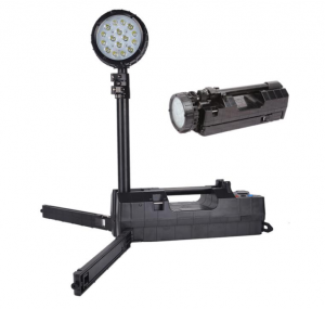
Portable waterproof and explosion-proof emergency light LT6117
Portable waterproof and explosion-proof emergency light LT6117 1.Overview Used for rescue scene lighting. The strong light condensing discharge time is ≥10h, and the working light condensing discharge time is ≥15h. It has the function of adjusting the intensity of condensing, flooding and concentrating. 2.Application Application of fire, emergency and other fields 3.Feature 1, the lamp has strong light, working light, flood light and other working states, and can ... -
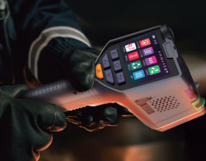
Multifunctional detector HRYXJ-A
Multifunctional detector HRYXJ-A 1.Overview Visual multifunctional detector is a comprehensive rescue equipment mainly used for emergency rescue site environmental state detection, early warning and data transmission, integrating infrared thermal imaging, visible light imaging, infrared temperature measurement, infrared ranging, wind speed measurement, gas detection, leakage detection and other functions in one. Provide integrated intelligent solutions for field command. The equipment... -
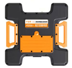
YSR-3D Three-dimensional radar life detector
1.Overview YSR-3D Three-dimensional radar life detector is composed of radar host (including battery), display control terminal, spare battery and charger.It is a portable and high performance wall-penetrating perspective system, which is used to obtain timely and accurate information of concealed personnel targets behind walls. The detector is unique in being able to provide a true three-dimensional image of the target behind the wall. This three-dimensional image is high resolutio... -
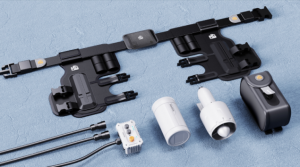
Wearable underwater thrusters LTD2
Wearable underwater thrusters LTD2 1.Overview The auxiliary propulsion equipment for divers underwater operations can save divers’ physical strength, improve divers’ underwater speed, expand divers’ underwater activity range, and free divers’ hands to facilitate underwater special operations.A hands-free wearable underwater thruster that redefines the underwater thruster with a breakthrough product design. Let you float and dive freely like a fish, swimming in ... -
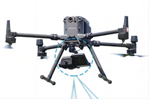
Flow measuring drone LT-CL30
Flow measuring drone LT-CL30 1.Overview It is used for rapid detection of rainstorm flood flow speed, especially water flow speed of levee break. With the monitoring system of UAV water velocity and flow, the flow velocity environment measurement is ≥20m/s. The UAV water flow meter integrates millimeter wave radar, which can carry out emergency water flow monitoring during flood season and heavy rain. Not affected by the monitoring environment, daily or emergency can be used anywhere....
