
Police & military equipment
-

LT-SVR1.0 Portable radio current meter
LT-SVR1.0 Portable radio current meter
I. Product Overview
The radio wave current velocity meter is an advanced velocity measurement instrument that uses radar technology to achieve simple and quick non-contact measurement of water surface velocity. The instrument is compact, lightweight, and easy to carry, making it highly suitable for on-site inspections in situations such as floods or rapid currents where it is difficult to use submerged measurement instruments.The radio wave current velocity meter integrates many leading technologies. For example, it uses a precise planar narrowband array radar sensor, FFT digital signal processing, flow velocity direction identification, automatic correction of vertical and horizontal angles, etc. The maximum flow velocity that this instrument can measure is 20 m/s, and it has high detection sensitivity. The current velocity meter is equipped with a large color LCD screen and embedded guided menu software, which is very convenient for users to operate.II. Product Features
- It is designed for single-person use, weighing less than 1 Kg, and can be held for measurement or placed on a tripod (optional accessory);
- It has a Chinese interface and is easy to operate;
- It adopts non-contact operation, is not affected by sediment, and is not corroded by water bodies;
- Automatic correction of angles in the horizontal and vertical directions;
- Multiple measurement modes, enabling both quick measurement and continuous measurement;
- It is equipped with a large-capacity built-in lithium-ion battery, which can be used continuously for more than 10 hours;
- Multiple charging methods are available, and it can be charged using an AC power source, a vehicle-mounted power source, or a mobile power source.
III. Main Technical Indicators
1. Measuring range: ≥ flow velocity 0.03 to 18.0 m/s;2. Temperature range: -30 to +70 °C;,3. Battery: 2800 mAh lithium-ion battery4. Weight: ≤ 1 kg;
5. Measurement accuracy: ±1% ± 0.03 m/s
6. Radio wave emission angle: 12°
7. Standard radio wave emission power: 10 mW
8. Radio wave frequency: 24 GHz
9. Angle compensation: Automatic for vertical angle
10. Storage capacity: 100 measurement results -

HRYXBSZ-384-A Explosion proof fire protection infrared thermal imager
HRYXBSZ-384-A Explosion proof fire protection infrared thermal imager
I. Product Overview
The HRYXBSZ-384-A fire-fighting infrared thermal imager is an infrared thermal imager specifically designed to assist firefighters in rescue or search work in low-visibility environments such as smoke or darkness. The product complies with the requirements of the Chinese public security industry standard XF/T 635-2023 “Infrared Thermal Imagers for Fire-fighting”.The HRYXBSZ-384-A fire-fighting infrared thermal imager adopts an advanced uncooled focal plane infrared detector and the advanced real-time infrared thermal image processing circuit independently developed by our company, and it can provide thermal images with high definition and high sensitivity. The HRYXBSZ-384-A fire-fighting infrared thermal imager has a handheld external structure, which conforms to the ergonomic design and can be operated with one hand.II. Product Features
- Automatic fusion of AUF infrared imaging and visible light
- 3.5-inch LCD touch screen
- WIFI interconnection
- High infrared resolution of 384*288
- Automatic capture of high and low temperatures
- Built-in LED fill light for clearer pictures
III. Main Technical Indicators
Testing Basis:
XF/T 635-2023 Infrared Thermal Imagers for Fire-fighting
Test Outline for Infrared Thermal Imagers for Fire-fighting
GB 4706.1-2005 Safety of Household and Similar Electrical Appliances – Part 1: General Requirements
Mass: 850g
Overall Dimensions of the Machine: 243mm * 103mm * 160mm
Temperature Measurement Range: Minimum temperature ≤ -40℃, Maximum temperature ≥ 1500℃
Temperature Measurement Accuracy ≤ ±4% of the reading
Detection Modes: The device has detection modes such as iron red, rainbow, gray-white, white-gray, blue-red, hot-cold, feather red, tan, and custom modes.
The device has a one-click photo-taking function.
The device can track the highest and lowest temperatures and display the temperature values on the screen in real time.
After the thermal imager freely drops from a height of 2 m to a hard ground once in each of the three directions (X/Y/Z), the thermal imager functions properly.
After the vibration test, the thermal imager functions properly.
The device is equipped with two batteries.
Screen Color Modes: Three modes, namely infrared image, visible light image, and picture-in-picture fusion function (fusion of visible light image and infrared image)
Monitor: 3.5 inches
Infrared Resolution: 384*288
Display Image Refresh Rate: 60Hz
Field of View: 49.2°*36.3°
Protection Level: IP68
Continuous Working Time in Specific Environmental Temperatures: 30 minutes at 80℃, 10 minutes at 120℃, 5 minutes at 260℃
Standard Working Time: ≥ 4h
Leakage Current: ≤ 0.5mA
It can withstand a voltage of 1250 V of a basic sine wave with a frequency of 50Hz for 1 minute without breakdown or flashover during the test.
Explosion-proof Mark: Ex ib ⅡC T6 Gb /Ex ib ⅢC T80℃ Db -

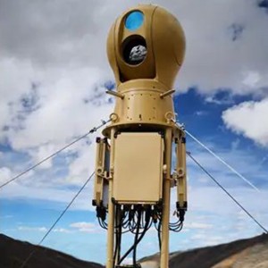
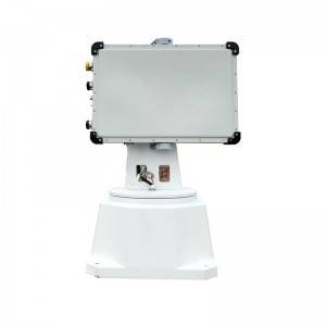
PSR-5000X Wireless Remote Control Mobile Panoramic Slope Monitoring Radar
PSR-5000X Wireless Remote Control Mobile Panoramic Slope Monitoring Radar
I. Product Overview
The PSR-5000X Emergency Ultra-Portable Slope Monitoring Radar is based on the circular synthetic aperture radar system, wideband frequency-modulated continuous wave signal form, and phase differential interferometric measurement technology. It has the characteristics of all-round 360° large-scale coverage, fine deformation measurement, and all-day and all-weather environmental adaptability. At the same time, especially for the rapid response requirements of emergency rescue tasks, it focuses on the design of being lightweight, small-sized, portable, and low-power consumption, forming industry-leading indicators in terms of volume, weight, power consumption, and portability.
II. Product Features
(1) The deformation measurement accuracy reaches 0.1mm, and the highest data update rate is 30 seconds per time, with high sensitivity in deformation monitoring.
(2) It has strong microwave penetration and the ability to monitor all day and all weather, without being affected by rain, snow, fog, smoke, dust, etc.
(3) Adopting the circular arc imaging and continuous wave radar system, it can monitor 360° in all directions, with no blind areas in terms of angle and distance.
(4) The body adopts an edge computing architecture, and all information processing is completed inside the body. A satellite gyrocompass (optional) and a wireless router (optional) can be built-in to achieve single-unit deployment and work, making the installation and configuration quicker.
(5) It has the function of remote control for electric pitch angle adjustment (optional), which can be flexibly adapted to the monitoring of high mountain valleys with large drops.
(6) It is extremely lightweight and portable, weighing only 8kg. It can be carried quickly to the rescue site by a single person either by hand or on the back. After folding, the size is only 0.5×0.3×0.25m, and it can be placed in a 24-inch storage and transportation box, meeting the requirements for random checked baggage on civil aviation flights.
(7) The software adopts a B/S architecture. It can be monitored on-site through a LAN/WiFi display and control laptop, or remotely monitored through the 4G/5G mobile network in the cloud.
(8) It has an original and advanced adaptive atmospheric disturbance compensation algorithm, with the error caused by atmospheric disturbance being less than 2mm per day.
(9) It has an original adaptive monitoring and early warning function. Monitoring points and monitoring areas can be added manually or automatically, and it has 4 levels of audible and visual, SMS, and email alarms that can be set.
(10) It has an original three-dimensional terrain matching and rendering algorithm, with a fast rendering time. The three-dimensional terrain matching accuracy reaches the sub-meter level, and the computer configuration requirements are low.
(11) It has good environmental adaptability, with a protection level of IP66. The lowest working temperature can reach -40℃ (with the optional low-temperature kit), and it supports continuous outdoor work without protection.III. Main Technical Indicators
(1) Maximum Detection Distance: ≥ 5000m
(2) Deformation Accuracy: ≤ 0.1mm (RMS, at all azimuth angles)
(3) Single Scan Coverage Angle: ≥ 360°×40°
(4) Electrically Controlled Pitch Adjustment Angle: ≥ ±45°
(5) Range Resolution: ≤ 0.3m (at all azimuth angles)
(6) Azimuth Resolution: ≤ 7.5mrad (at all azimuth angles)
(7) Acquisition Period: Configurable between 0.5 and 4 minutes
(8) Power Consumption of the Whole Machine: ≤ 45W
(9) Weight of the Whole Machine: ≤ 8kg
(10) Maximum Size after Folding and Storage: ≤ 0.5m
(11) Transportability: Can be carried by a single person by hand and can be checked in on flights and high-speed trains.
(12) Operating Temperature Range: -40~55℃
(13) Protection Level: ≥ IP66
(14) The main unit adopts edge computing, and all processing is completed inside the machine without the need for external processing equipment.
(15) The main unit has a built-in satellite gyrocompass, which supports independent positioning and orientation, making the deployment convenient and quick.
(16) The main unit has a built-in WiFi/4G wireless communication function, eliminating the need for additional communication equipment.
(17) It comes with a sunshade and has a built-in automatic hot and cold temperature control system.
(18) It supports the reinforcement and stabilization of each leg of the tripod with heavy objects.
(19) It has means for quickly obtaining and processing three-dimensional terrain temporarily, which is convenient for emergency tasks.
(20) It is equipped with a power grid protection transport box, with a built-in storage battery (an offline battery life of 72 hours, and it can be used while charging). It can be connected to an external solar panel and mains power (automatically switches to the storage battery when the mains power is cut off), and has a backup network access (the weight of all transport boxes ≤ 35kg). -

PSR-3500-S Rolling Stone Radar/ Portable Sudden Geological Hazard Monitoring Radar
PSR-3500-S Portable Sudden Geological Hazard Monitoring Radar
I. Product Overview
The PSR-3500-S Portable Monitoring Radar for Sudden Geological Disasters is a portable alarm system for sudden geological disasters that adopts large-scale MIMO array technology and advanced moving target detection algorithms, and integrates technical means such as radar, audible and visual alarms. It can continuously monitor large-scale slopes, and provide real-time alarms for rockfalls, debris flows, and collapses. It has the advantages of good environmental adaptability, wide coverage, fast update, quick positioning, and being suitable for single soldiers to carry.
II. Product Features
- Ultra-long distance and large-scale detection
With a long distance of 3.5 kilometers, and the monitoring accuracy is not affected by the distance. - Ultra-high precision monitoring
With a maximum sub-millimeter level accuracy of 0.1mm, it can finely monitor early slight deformations and provide faster and more accurate warnings. - Multi-functional detection
Integrates audible and visual alarms and multiple sensing detections by radar. - Ultra-high speed monitoring
With a moving target monitoring speed of 10m/S, it can quickly identify potential falling objects. - All-day, all-weather, fully automated detection
It can conduct 24-hour, all-day, all-weather, and fully automated detection. - Lightweight
The whole machine adopts an integrated, lightweight and small handheld design, which is easy to transport and deploy.
III. Main Technical Indicators
3.1 Main Unit Parameters:- Maximum Monitoring Distance: 3500M
- Maximum Monitoring Distance for Moving Targets: 1500M
- Deformation Monitoring Accuracy: Sub-millimeter level, 0.1mm
- Maximum Moving Detection Speed: 10m/S
- Acquisition Interval: 1-6min
- Resolution: 0.3m×3mrad
- Monitoring Range: 120°;
- Data Acquisition Time: ≤1min
- Monitoring Conditions: 24 hours, fully automatic detection
- Power Supply Requirements: AC220V/DC 48V.
- Protection Level: IP66;
- Operating Temperature: -30℃ — 60℃;
- It has a hardware self-recovery function, and a repair interface is reserved. Repair accessories can be inserted to automatically restore the factory settings;
- It is equipped with radar data playback software, which can automatically play back the echo signal waveform and view the calibration signal;
- It has a built-in GNSS function and can achieve differential positioning;
- It has an automatic orientation function;
- It has the timing function of the Beidou Satellite Navigation System at the atomic clock level, and the frequency accuracy is better than ±0.5ppb (measurement result within 24 hours);
- The radar system is integrally integrated with a camera for scene monitoring. The connection line between the camera and the radar system is not exposed. The video monitoring function interface and the radar system control system interface are integrally integrated, and the scene image can be captured through the radar system control system interface;
- The system connection is simple. The connection lines of each functional module of the radar should preferably be routed inside the system, and the number of connection cables of the entire radar system is ≤4.
4.2 Software Parameters: - Data collection and deformation processing are directly carried out at the local end, and the automatic processing of radar echo imaging, interference processing, and micro-deformation inversion is completed;
- The software can identify the running status of the radar and the azimuth positioning mechanism, and the running status of the azimuth positioning mechanism and the scanning running position can be viewed in real time through the software;
- It can realize the registration of radar monitoring data and the three-dimensional terrain, and automatically register according to the submitted point cloud data; it supports the integration of UAV modeling, CAD three-dimensional modeling, laser three-dimensional point cloud modeling data and radar data;
- Effectively manage the monitoring data, and be able to query and analyze the data by time, day, week, month, etc.;
- Provide a three-dimensional visual operation interface, and users can conduct data analysis of single points and regions;
- Provide analysis methods for displacement, speed, and acceleration by point and by region;
- Have the functions of deformation color display, email alarm, and SMS alarm warning methods;
- The functions of displaying deformation values, deformation speeds, and acceleration curves in the ways of extreme values and averages can be selected. They can be displayed separately in the ways of extreme values and averages, or can be displayed in combination;
- Provide the setting of alarm thresholds for alarm variables such as deformation values, deformation speeds, deformation accelerations, and cumulative deformation values. The selection of alarm variables can be a single one, or any combination of them, and the alarm time interval can be set;
- The monitoring area selection methods include straight-line polygons, curved-line polygons, etc. It can indicate the positions of at least three points with the maximum deformation in the area, and can display the deformation, deformation speed, and deformation acceleration curves of the point with the maximum deformation;
- Be able to diagnose the overall running status of the radar system and provide status and diagnostic information, be able to monitor the radar waveform status, data coherence quality, and scanning position running status in real time, and achieve rapid positioning of faulty modules;
- Provide a variety of data display and query methods: real-time data, daily data, weekly data, monthly data, annual data;
- Have the functions of distributed correction of space-varying atmospheric phase and multi-level slope interference phase unwrapping;
- Be able to diagnose the overall running status of the radar system and provide status and diagnostic information, be able to monitor the radar waveform status, data coherence quality, and scanning position running status in real time, and achieve rapid positioning of faulty modules.
- Ultra-long distance and large-scale detection
-
Drone robotic arm LT-30
. Product overview The LT-30 drone robotic arm set comprehensive, smart and precise operation, convenient installation, ultra-low power consumption, stability of outdoor use, etc., can achieve high load air capture and transfer, comprehensive high and low pressure spraying, contact type press detection detection The functions of accurate sampling and distribution of gas liquid solids, while providing rich tool expansion, empowering energy operation and maintenance, ... -
Dual light high -definition night vision gas reconnaissance detection drone
1. Product overview The drone can quickly obtain the global perspective of the disaster accident scene. Some scenes can replace artificially close to reconnaissance. Through the hot imaging camera and the smoke to identify the fire points and high temperature areas, in the rescue of the hazardous chemical tanks, large -scale mountain fires The efficiency of rescue and fire extinguishing is greatly improved in the scenes such as combustion, which has an important promotio... -
SR223D1 UAV drone detection radar system
1.Product function and use The D1 radar is mainly composed of a radar array high-speed turntable and a power distribution control box. It is used for the detection of low-altitude, low-speed, small and slow targets and pedestrian vehicles. It can be used for alert and target indication, and can give real-time and accurate target track information. a) The radar adopts a fully automatic detection and tracking working method, and the terminal display and control platform software reali... -
Impact robot
Overview Impact robot is mainly used for video surveillance, military deterrence, and remote strikes against illegal elements such as terrorists, criminals, and poachers, collaborating with public security and armed police to carry out anti-terrorism tasks, and assisting special operations personnel to carry out border patrol tasks. Scope of application Applied in the anti-terrorism field of the armed police Features 1. Convenient loading: modular design, convenient and quick installation and... -
5km Unmanned Aerial Vehicle Uav Detection Radar Drone Surveillance Radar
1.Product function and use SR223 radar is mainly composed of 1 radar array, 1 integrated control box and 1 turntable. It is used for detection, alert and target indication of micro/small civilian drones in key areas such as prisons, exhibitions, and military bases. The trajectory information such as the position, distance, altitude and speed of the target is given. 2.Main product specifications Item Performance parameters Work system Phased array system (azimuth machine scan + pitch phas... -
![All -color night vision drone load (thermal imaging+zoom camera+laser ranging meter) S3 [Adaptation of DJI M300M350RTK]](https://cdn.globalso.com/topskyeqpt/Pic16-300x300.jpg)
All -color night vision drone load (thermal imaging+zoom camera+laser ranging meter) S3 [Adaptation of DJI M300M350RTK]
1. Product overview Full -color night visual drone S3 is equipped with extremely weak light full -color AI imaging engine “Knowing Shadow® AIISP”, which can achieve full color high -definition night vision that surpasses star light. The thermal imaging camera, the zoom camera and the laser rangefinder are used, and the M300/M350RTK drone is used to realize the innovative application of a variety of drones night scenes and improve the efficiency and operation experience of ... -
Strong sound dispels the shouting drone
1. Product overview The maximum sound pressure can reach 140dB, the longest sound distance exceeds 1,000 meters. In the effective coverage area, the sound is clear and penetrating. It can effectively pass voice information to the target. Radio command scheduling in rescue scenarios. With a strong sound dispersion mode, it can be used for group events such as strong sound evacuation and strong sound driven birds at the airport. 2. Scope of application It is applied to em... -
Shouting and lighting drone
1.Product overview The shouting lighting drone has dual functions of shouting and lighting. After the drone fly to the target location, you can appease the rescuer and provide a stable light source for the rescue at night. On the one hand To confirm the goal, using the shouting device for air broadcasting, so as to quickly guide the trapped persons, effectively meet the needs of forest search and rescue task scene; Maritime fishing administration and other scenarios are also ...